Protecting Northeastern Coastal Resources
[TamilNet, Saturday, 16 November 2002, 02:14 GMT]
Northeast costline, approximately 1000 km long, is home to more than 30 estuaries and sustains a rich ecosystem. Northeast region has remained relatively unhindered by human activity and less affected by the degradation and depletion of coastal habitats usually caused by urbanization, economic growth and overdevelopment.
 |
|
Visible erosion of a beach
|
Coastal resources include the physical coastline, lagoons, adjoining wetlands and the ecosystem sustained around the coastal areas. Preventive measures to arrest shrinking landmass due to erosion and preserving the ecosystem is vital for maintaining the fine balance between the natural processes and human needs.
Waves driven by the Northeast and Southwest monsoons cause considerable erosion in NorthEastern coasts which face these winds. Polikandy, Katkovalam villages on the Northern sea coast, and villages of NagarKovil, Chempianpattu on the Vadamaradchy eastern shores bear the brunt of the monsoon winds.
Coastal habitats such as coral reefs, barrier islands and spits, estuaries and lagoons, mangrove forests, seagrass beds, sand dunes, salt marshes, and vegetated coastal wetlands dissipate wave energy and protect the coastal areas from flooding and erosion. Urbanization, dredging, sand removal and alterations done to beaches and estuaries threaten these habitats.
 |
|
Coral reefs dampen wave motion and dissipate wave energy
|
Management of coastal processes in Sri Lanka dates back to the 1920s with the primary focus on erosion control. However, with the establishment of Coastal Conservation Division (CCD) in 1978, and the Coastal Conservation Act (CCA) in 1981, Sri Lanka became the first tropical country to have a centrally managed integrated coastal zone management plan. The CCA provided the legal foundation to regulate development within the islands coastal zone - an area extending to 300 m inland from the mean high water line and 2 km seaward from the mean low water line. However, limited funds, over lapping jurisdictions, and political interference have hindered protecting the environment adequately.
Coral reefs -more than 150 different types- account for 2% to 3% of the total Northeastern shoreline, with high concentrations off the Eastern coast. Mining coral for conversion to lime, over exploitation of reef organisms, chocking by increased freshwater run-off and sediments, and physical damage by boats or by dynamite explosions provide threat coral reefs.
 |
|
Barrier beaches preventing damage to main shoreline
|
In coastal villages of Kalkuda, Pasikuda, Kayankerni and Mankerni north of Batticaloa town poor villagers mine coral heavily for selling to lime kiln owners. Pasikuda is worst affected by erosion where many coastal roads have been destroyed and several wells have turned saline due to coastal erosion. Casuarina beach in the Northern islands is also noted for its coral reefs.
Unconsolidated sediments transported by waves form 'Barrier islands' that lie across the direction of waves providing protection against erosion . There are many barrier beaches within the Northeast coastal zone. Though large storms tend to wash away parts of barrier beaches, human activity such as sand removal pose significant threat to the barrier beaches.
 |
|
A typical estuary that supports a rich ecosystem
|
High nutrient loading and water circulation patterns in estuaries, the river mouths to the ocean/lagoons, support many commercially important organisms such as shrimp and fish. Encroachment and changes in effluents from closeby urban centers threaten estuaries and their ecosystems. Estuaries also degenerate from changes in sedimentation patterns or salinity regimes, waterborne pollutants, destruction of submerged or fringing vegetation and inlet modification.
Per Aru (Mullaitivu district, joins Nanthikadal), Kanagarayan Aru (Mullaitivu district, joins Jaffna lagoon), Parangi Aru (Mannar district, joins Gulf of Mannar), and Aruvi Aru (Mannar district, joins Jaffna lagoon) are rivers with large catchment area and having estuaries in the NorthEast district. One of the larger estuaries of Mahaweli ganga, the longest river in the island, is at Koddiar bay where it joins the Indian Ocean.
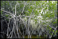 |
Mangrove trees are common protectors of vulnerable shorelines
(Photo: www.terragalleria.com)
|
Mangrove forests provide flood protection, erosion control, and nursery areas for fish and shrimp. 23 different species, are found scattered mainly along the northwestern, northeastern and eastern coasts, in lagoons and estuaries. In Chillow mangrove forests were destroyed to give way to prawn culture ponds. Over harvesting of mangroves, siltation, pollution, and changes in fresh water runoff can also damage mangrove forests.
South of Mannar Island, extending for several kilometers lie well known Pearl Banks, breeding grounds of true pearl oyster. Though pearl banks have been inactive for many years plans are in progress to resume commercial pearling. Proper oversight of commercial enterprises is necessary to avoid environmental damages.
 |
|
Seagrass in shallow waters and wetlands(Photo: www.terragalleria.com)
|
Seagrasses are rooted marine plants that grow in low-energy coastal zones near the shore. They are found in northeastern and northwestern coastal zones. Seagrass stabilizes sediments and serve as nursery areas to fish and shrimp. Damages to seagrass are caused by the use of drag nets and push nets for fishing, and sedimentation.
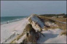
Sand dunes are wind blown accumulations of sand occurring on the coastal zone. Dunes lying behind the beach are the second line of defense against waves caused by storms, although they may be washed away by larger storms. They act as buffers to waves and erosion as well as provide partial protection against wind damage caused by cyclones. Damages to dunes are caused by sand removal. Shifting sand dunes are observed in Vallipuram and Manalkaadu, villages that lie within 5 km south of Point Pedro.
 |
|
Sand dunes in danger of erosion damage (Photo: Darryl Hatheway)
|
Vegetated coastal wetlands, rare in open coastal areas, are generally found near estuaries. They are subjected to coastal flooding infrequently, caused by storms of smaller recurrence, such as a 100-year storm. When such events occur, the wetland vegetation causes the waves to dampen and break, thus dissipating much of the wave-energy. The root system of coastal wetland vegetation bind and protect the soil from erosion and provide a buffer to pollution associated with salt water flooding.
Prolonged saltwater flooding can endanger the dwindling ground water aquifers inland. Areas of Pooneryn and Thondamannar have suffered from salinity creeping progressively inland endangering fresh water acquifers that supply drinking water.
As development of Northeast gains momentum wider public awareness of the need to preserve coastal resources, establishment of sound environmental policy, and its strict implementation become imperative for safeguarding the environment for future generations.


